Google Maps has seen widespread adoption among the populace thanks to the fact that it can be run on the majority of consumer-grade electronic devices including smartphones, tablets, and laptops. If a device can run the software and is connected to the internet, chances are it can access at least some of the essential features of Google Maps.
In addition to this basic functionality, Google Maps offers a slew of additional options that most of its users aren’t even aware of. These provide additional functionality beyond the basics, and some are also so useful that it is a surprise they haven’t become more prominent. So in the rest of this article, we will give you a quick overview of 7 features we feel deserve more love and attention than they have been getting.
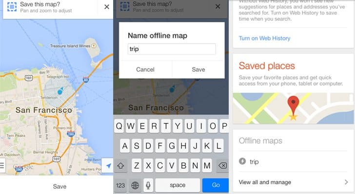
1. Offline Map Access
The majority of Google’s software is based on functionality, so the option to access Maps offline might come as a surprise to some people. This practical feature can come in handy in several situations. Data-caps are still a reality for a lot of individuals, especially for mobile users, so saving maps offline is a great way to keep on bandwidth. Travelers going to places without internet access can also benefit from saving a map or two of their destination. Finally, accessing data from local storage is much quicker than downloading, so using offline maps can save you a lot of time and effort in the long run.
2. Voice Search
Glancing at a map while driving is not only difficult, but it can also be hazardous, especially if your map is on a tiny phone screen. In situations where you absolutely have to consult a map while on the road, you can use Google Maps’ built-in voice search functionality. It is programmed to recognize a number of common voice commands in a variety of languages, so you can keep your eyes on the road and hands on the wheel while navigating. You can also use voice commands to make calls, send texts, play music while driving, combining roadside safety with convenience.
3. Google My Business Integration
Google Maps works in tandem with many other Google services, including Google My Business (formerly known as Google Places). The latter allows businesses to get listed for appearing in location-based searches, similar to how a website is crawled for a chance to appear on a search engine results page. If your business is already using Google’s services, setting up your Google My Business profile takes only a few steps. Otherwise, setting up a Google My Business listing can be handled by an SEO services company specializing in local search. Google My Business can also be used for market research to get information about competing businesses in your local area.
4. Share Location Data
Most online-based software today has some form of built-in social network functionality, and Google Maps is no different. You can share your location data with select people from your contact list while you are at a particular location, for a pre-determined amount of time. You can also share step-by-step directions to a specific location such as an event, making navigation a breeze. If you have security concerns related to sharing location data, you can always modify your app permissions to limit what can be shared and when.
5. Indoor Directions
Most users associate Google Maps with outdoor use. In reality, the application offers indoor maps of many public buildings as well such as airports, museums, sports arenas, hospitals, universities, and other locations with a complex internal structure. There is the option to scroll through multiple floors and points of interests such as bathrooms or elevators marked by specific icons. Standard navigation options such as displaying the shortest possible route are also available. The application can seamlessly pass from outdoor to indoor view as well.
6. Display Traffic Data
Having access to up-to-date traffic information is essential for a lot of jobs, whether it helps you be at the right place in the shortest amount of time, or by providing the most efficient route to your destination. Google Maps offers two options for displaying traffic data depending on the location. For some areas, you can access live traffic stats which reflect current roadside conditions with a reasonable degree of accuracy. In others, your only option is finding out typical traffic levels at different times during the day.
With the help of Google Maps commercial route, as more people start using Google location services, traffic predictions are bound to give more relevant traffic predictions.
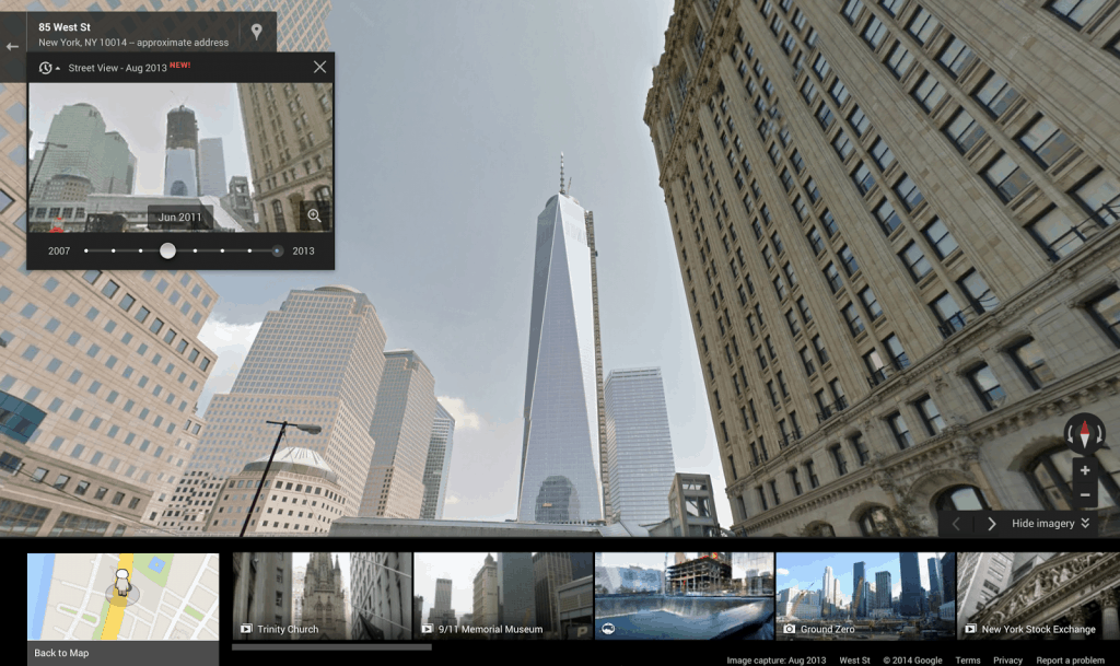
7. Street View History
At this point, everyone is at least aware of the Street View functionality of Google Maps, which gives you the option to survey a location like you are there. What people don’t usually know is that Street View can also display data from different points in time, giving you the ability to track changes a location has undergone through time. The feature is highly dependent on location, but in places it does work, it can bring up whole years worth of data. While this feature has limited practical use at the present moment, it can provide valuable data for research purposes down the line.
Say Goodbye to the Physical Map
Google Maps have all but replaced conventional maps as a chief tool for navigation in everyday use. This powerful piece of software combines the functionality of a stack of maps, a GPS system, and a tourist guide to provide comprehensive information about your locale, including traffic data, navigation guidelines, event and place suggestions, and more. Check out Google Maps’ features right now, and you will get some inspiration on how to properly use this excellent tool.